The Center for Strategic and International Studies (CSIS) is a bipartisan, nonprofit policy research organization dedicated to providing strategic insights and policy solutions to help decisionmakers chart a course toward a better world. The Andreas C. Dracopoulos iDeas Lab (iLab) enhances CSIS's research with the latest in cutting-edge web technologies, design, and video.
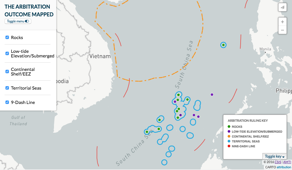
In 2016, the CSIS iDeas Lab produced a collection of interactive maps in order to visualize some of the world's most complex policy debates. The objective of these maps are to illustrate, educate, and inform policymakers, the private sector and the public about critical geopolitical issues including patterns of global terrorism, missile proliferation in Eastern Europe, infrastructure development in Central Asia, and land reclamation in the South China Sea.
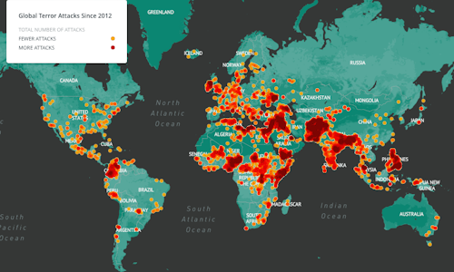
For the CSIS Commission on Countering Violent Extremism (CVE), the iLab sought to build a product that would visualize the global threat of violent extremism. Using open-source data compiled by the University of Maryland's Studies of Terrorism and Responses to Terrorism (START) Global Terrorism Database, the iLab produced the first, non-classified and publicly available interactive map of terrorism incidents. The map is powered by a CARTO geodatabase, and uses a custom-built MapBox layer to display the information in a user-friendly format.
Working with the CSIS Missile Defense Project, the iDeas Lab built an interactive map that displays Russian and NATO overlapping missile and missile defense systems in Eastern Europe, thus visualizing the critical policy issues currently being debated surrounding the concept of Anti-Access Area Denial (A2AD). Produced entirely in-house, the interactive map allows users to select and deselect information layers to gain a better understanding of the missile defense environment in Eastern Europe, and the challenges facing NATO.
Because it visualized the global threat of violent extremism, the iDeas Lab CVE interactive map accumulated over 17,000 map views in its first week, and over 50,000 map views since it launched in November 2016.
At a larger scale, in part due to wider media coverage, the A2AD interactive map launched in early January 2017 and has accumulated over 1,000,000 map views to date.
Other mapping products by the CSIS iDeas Lab include the Reconnecting Asia infrastructure map, and the CSIS Asia Maritime Transparency Initiative (AMTI) South China Sea tracker maps. In total, CSIS iDeas Lab interactive maps received over 4.5 million map views in 2016.